
September 18th Turkey Creek Black Canyon Run
 09-01-2010, 06:38 PM
#1
JK Enthusiast
Thread Starter
Join Date: May 2008
Location: Phoenix, AZ
Posts: 487
Likes: 0
Received 0 Likes
on
0 Posts
Turkey Creek / Black Canyon
Trail Rating: 3.5
The Turkey Creek Trail runs through the Black Canyon in the Bumble Bee area of the Bradshaw Mountains. There are many roads, tracks and trails in this area. It is well advised to with an experienced trip leader until you become familiar with this beautiful but rugged area.
There will be rocky areas to play on along the way. If the river is running, you'll want to make sure you have a winch along, as there are boulders and quick sand hiding, waiting to bite a Jeep. About the 4th crossing you come to will be the toughest. If there is alot of water, stay to the left, then cut back to the right about 75 feet before land. If you continue down the creek (left) you will sink your rig. Be very cautious. You will come to two obstacles (right of the creek). The first is the "ditch rock" because you have to go through a ditch that may be filled with water, then come back up to climb through a rocky spot. The second obstacle right after that is "the squeeze" where you have to maneuver through about 50 feet of tightly spaced rock. After these two obstacles, there isn't much else to worry about. Keep following the wash up, eventually the road will become more apparent. The trail takes a steep climb out to the top of a ridge, then drops off the other side. You will come to a Y intersection, you may go either way. The left branch climbs another ridge and then drops you back into the wash on the other side.
The right branch takes you through Bob Reaves' mining claim. Bob lives in the historic cabin, originally built back in the 1800's. If you have time to stop by the cabin, Bob will give you a little history of the area. He does enjoy visitors and will like for you sign into his guest book. He is a volunteer for the BLM and a very nice guy. Be sure to tell him you belong to the Arizona Virtual Jeep Club.
The trail on the right branch almost completely disappears; pick your way through carefully you'll find rocky flat areas with no brush on them, this is the trail. After passing around the corner from Bob's cabin, you'll see where the trail used to go across a bend in the wash; now that is pretty much impassable. You can continue up the wash and around the corner. If the water is running, this may be extremely hazardous.
After the bend, the two trails combine again. The trail is much more visible now, there will be a few places where the trail splits, take the most travelled looking trail. Go SLOW one of these side trails (the old trail) has about a four foot angled drop off as you come around a blind curve. (If you get here turn around and cross the creek).
The further you go, the more apparent the trail is. At the joining of Poland Creek and Turkey Creek, the trail leaves the bottom of the canyon and heads across the hills to Cleator. Overall, with a small group of Jeeps, this trail can be done between 4 - 6 hours when dry depending on how much site seeing you do. If it is really wet, this can be a weekend trip.
One note of caution, this trail runs almost entirely through active mining claims; do NOT stop and start digging around.
Remember to bring water, lunch (and more if it's wet), and don't forget your camera.

How to Get There:
Take I-17 North from Phoenix to the Bumble Bee Exit.
Head toward Bumble Bee; turn left onto FR 684 about 1/2 mile before Bumble Bee. If you cross the bridge just before Bumble Bee, you've gone to far. Its not the road that enters sheeps creek but the larger one before that. Marked 294 or something when headed south. Take the forks to the left which should take you down a switch back next the river.
*************Meeting at the I-17 and New River Road.
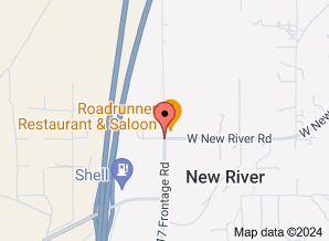
At the Roadrunner on the east side access road.....................
Roadrunner Bar
47801 North Black Canyon Highway, New River, AZ 85087-8163
They open at 7 AM, we can meet have breakfeast or meet and roll......................Let's get a time together on when to me 6-7 AM I think would be best.
People going:
Crazey Casey
Rustler
*****************************
Trail Rating: 3.5
The Turkey Creek Trail runs through the Black Canyon in the Bumble Bee area of the Bradshaw Mountains. There are many roads, tracks and trails in this area. It is well advised to with an experienced trip leader until you become familiar with this beautiful but rugged area.
There will be rocky areas to play on along the way. If the river is running, you'll want to make sure you have a winch along, as there are boulders and quick sand hiding, waiting to bite a Jeep. About the 4th crossing you come to will be the toughest. If there is alot of water, stay to the left, then cut back to the right about 75 feet before land. If you continue down the creek (left) you will sink your rig. Be very cautious. You will come to two obstacles (right of the creek). The first is the "ditch rock" because you have to go through a ditch that may be filled with water, then come back up to climb through a rocky spot. The second obstacle right after that is "the squeeze" where you have to maneuver through about 50 feet of tightly spaced rock. After these two obstacles, there isn't much else to worry about. Keep following the wash up, eventually the road will become more apparent. The trail takes a steep climb out to the top of a ridge, then drops off the other side. You will come to a Y intersection, you may go either way. The left branch climbs another ridge and then drops you back into the wash on the other side.
The right branch takes you through Bob Reaves' mining claim. Bob lives in the historic cabin, originally built back in the 1800's. If you have time to stop by the cabin, Bob will give you a little history of the area. He does enjoy visitors and will like for you sign into his guest book. He is a volunteer for the BLM and a very nice guy. Be sure to tell him you belong to the Arizona Virtual Jeep Club.
The trail on the right branch almost completely disappears; pick your way through carefully you'll find rocky flat areas with no brush on them, this is the trail. After passing around the corner from Bob's cabin, you'll see where the trail used to go across a bend in the wash; now that is pretty much impassable. You can continue up the wash and around the corner. If the water is running, this may be extremely hazardous.
After the bend, the two trails combine again. The trail is much more visible now, there will be a few places where the trail splits, take the most travelled looking trail. Go SLOW one of these side trails (the old trail) has about a four foot angled drop off as you come around a blind curve. (If you get here turn around and cross the creek).
The further you go, the more apparent the trail is. At the joining of Poland Creek and Turkey Creek, the trail leaves the bottom of the canyon and heads across the hills to Cleator. Overall, with a small group of Jeeps, this trail can be done between 4 - 6 hours when dry depending on how much site seeing you do. If it is really wet, this can be a weekend trip.
One note of caution, this trail runs almost entirely through active mining claims; do NOT stop and start digging around.
Remember to bring water, lunch (and more if it's wet), and don't forget your camera.
How to Get There:
Take I-17 North from Phoenix to the Bumble Bee Exit.
Head toward Bumble Bee; turn left onto FR 684 about 1/2 mile before Bumble Bee. If you cross the bridge just before Bumble Bee, you've gone to far. Its not the road that enters sheeps creek but the larger one before that. Marked 294 or something when headed south. Take the forks to the left which should take you down a switch back next the river.
*************Meeting at the I-17 and New River Road.
At the Roadrunner on the east side access road.....................
Roadrunner Bar
47801 North Black Canyon Highway, New River, AZ 85087-8163
They open at 7 AM, we can meet have breakfeast or meet and roll......................Let's get a time together on when to me 6-7 AM I think would be best.
People going:
Crazey Casey
Rustler
*****************************
Last edited by Rustler; 09-02-2010 at 05:21 AM.


 09-07-2010, 10:20 AM
#4
JK Super Freak
Join Date: Feb 2010
Location: New River/ Phoenix,AZ
Posts: 1,214
Likes: 0
Received 0 Likes
on
0 Posts
09-08-2010, 09:34 PM
#6
JK Super Freak
Join Date: Feb 2010
Location: New River/ Phoenix,AZ
Posts: 1,214
Likes: 0
Received 0 Likes
on
0 Posts
there wont i was up there 10 days ago and the deepest part i found was about 2 feet. i dont plan on running the first part up the creek... unless you want too.... too many newly deposited obstacles from last springs flood. there is a road that will drop us down and we only have to cross through the wash.... which when I was up there 10 days ago only had 6-8 inches of water in it.

